Support quality, independent, local journalism…that matters
From just £1 a month you can help fund our work – and use our website without adverts. Become a member today
Natural Resources Wales has urged residents to be “vigilant and prepared”, with Storm Bram expected to bring flooding and disruption to Wales.
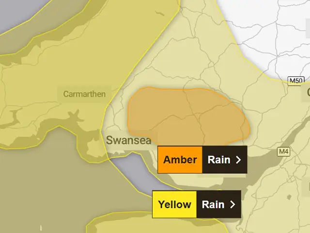
A Met Office amber warning for rain will be in place for parts of south Wales from midnight until 10am on Tuesday December 9, covering large parts of Caerphilly County Borough.
A Yellow warning for rain for Wales is in force from 6pm on Monday December 8 until 2pm on Tuesday – with a Yellow warning for wind covering large parts of Wales from 10pm on Monday until 4pm on Tuesday.
What are amber and yellow weather warnings?
Yellow Warning: Yellow warnings can be issued for a range of weather situations. Many are issued when it is likely that the weather will cause some low level impacts, including some disruption to travel in a few places. Many people may be able to continue with their daily routine, but there will be some that will be directly impacted and so it is important to assess if you could be affected. Other yellow warnings are issued when the weather could bring much more severe impacts to the majority of people but the certainty of those impacts occurring is much lower. It is important to read the content of yellow warnings to determine which weather situation is being covered by the yellow warning.
Amber Warning: There is an increased likelihood of impacts from severe weather, which could potentially disrupt your plans. This means there is the possibility of travel delays, road and rail closures, power cuts and the potential risk to life and property. You should think about changing your plans and taking action to protect yourself and your property. You may want to consider the impact of the weather on your family and your community and whether there is anything you need to do ahead of the severe weather to minimise the impact.
Red Warning: Dangerous weather is expected and, if you haven’t already done so, you should take action now to keep yourself and others safe from the impact of the severe weather. It is very likely that there will be a risk to life, with substantial disruption to travel, energy supplies and possibly widespread damage to property and infrastructure. You should avoid travelling, where possible, and follow the advice of the emergency services and local authorities.
Source: Met Office
Natural Resources Wales (NRW) has said its teams are working alongside the Flood Forecasting Centre, emergency responders, and councils to prepare for this weather, and monitor forecasts and rainfall predictions.
Charlotte Morgan, NRW’s duty tactical manager, said: “We are asking people to be alert for potential flooding with heavy rain predicted through Monday and overnight, especially in parts of south Wales.
“We’re urging people to be vigilant and to prepare for potential flooding now. You can check if you live in an area at risk of flooding on our website and sign up for our free flood warning service.
“We also want to remind people to keep away from swollen riverbanks and not to drive or walk through floodwaters as you don’t know what lies beneath.”
Ms Morgan continued: “We are expecting to see very large waves and are advising people to stay clear of promenades and seafronts as you could be swept away by large waves or hit by debris.
“Our thoughts are with those communities who have recently been impacted, and they could potentially be impacted again during this event.”
Flood alerts and flood warnings are updated on the NRW website. Information and updates are also available by calling its Floodline on 0345 988 1188.
Support quality, independent, local journalism…that matters
From just £1 a month you can help fund our work – and use our website without adverts.
Become a member today